Adjustment Summary Dialog
GeoLab’s Adjustment Summary Dialog is a useful tool used to analyze the results of an adjustment and aid in the removal of potential blunders and bad observations from the adjustment process.
Overview
There are three main components to the adjustment summary:
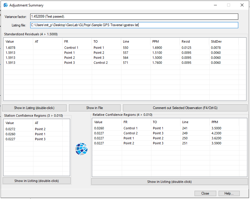
Station Confidence Regions: Flagged error ellipses corresponding to station accuracy data.
Relative Confidence Regions: Flagged error ellipses corresponding to observation accuracy data.
Standardized Residuals: Flagged observation quantities
These are flagged and ordered primarily based on their Standardized Residual value, which compares their residual against their standard deviation.
All relevant quantities are populated in the appropriate boxes, with the following fields:
At: at-station (if relevant)
From: from-station
To: to-station
Line: spatial distance of line, in meters
PPM: spatial error in parts per million (mm per km)
Resid: residual magnitude in meters (arc-seconds for angular observations)
Std: standard deviation value in meters (arc-seconds for angular observations)
Usage

Double-click on any of the flagged quantities in the adjustment summary to automatically scroll to the corresponding observation in GeoLab’s Listing file.
Alternatively, click the Show in Listing button.
Click the Show in File button with a highlighted standardized residual to instead open the corresponding input file and scroll down to the appropriate observation.
The Variance Factor box displays the final variance factor of the adjustment, which is a factor of the residuals will ideally equal 1.0. In addition, a statistical test (default of Chi-square) is applied to the variance factor to determine whether it is statistically acceptable.
The Listing File box displays the filepath of the corresponding adjustment Listing File.
Removing Observations
One way you can remove observations is by double-clicking on its corrresponding residual to navigate to it in the listing file, as mentioned above. Once you find the group identifier or observation number, you can find said observation in its corresponding input file and comment it out.
Alternatively, the Comment out Selected Observation button will automatically navigate to and comment out whatever observation(s) are selected in the observations (Standardized Residuals) box, in their appropriate input files. This is a quick and easy way of removing observations without needing to scroll through files to find them.
If multiple standardized residuals are selected, all the corresponding observations will be commented out.
If the corresponding observations are already commented out, they will instead be un-commented and brought back into the adjustment.
Flagging
"Flagging" is what is done to confidence regions or observations if their uncertainty surpasses a particular threshold, identifying them as potentially erroneous. The adjustment summary dialog only shows quantities from the adjustment that have been flagged.

You can control which confidence regions and observations are flagged using the appropriate controls in the Project Options dialog.
In addition, these flagging factors are used to control which observations are removed through SmartAdjust and the GeoLabAPI.