Geoids
The geoid is a global equipotential surface that coincides with the average level of the undisturbed level of the oceans. It is used as a reference surface for orthometric heights. The geoid is specified in terms of geoidal undulations, or heights of the geoid above a specified reference ellipsoid.
GeoLab ships with four world-wide geoid files that you can use right away. If you need to use any other geoids, please feel free to download any of those listed below or provide your own.
Important Disclaimer: With respect to GSP files and geoid files available from or through links on this web site, neither GeoLab Solutions nor any employees of GeoLab Solutions make any warranty, express or implied, including the warranties of merchantability and fitness for a particular purpose, or assumes any legal liability or responsibility for the accuracy, completeness, or usefulness of any information, product, or process disclosed, or represents that its use would not infringe privately owned rights.
About GSP Files
For each geoid file in the tables below, you can download the GSP file for that geoid. A GSP file is a small file that GeoLab uses to interpret the contents of the corresponding geoid data file.
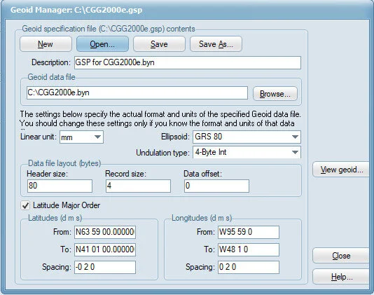
When you run the Geoid Manager (Project/Tools/Geoid Manager) and load a GSP file (using the Open button), you will see the dialog displayed at the right. The left side of this dialog displays the information contained in the GSP file. For example, the "Data file layout" group specifies how the geoid binary data file is structured. You must not change this data in a downloaded GSP file because the GSP file will then not describe the contents of the geoid binary file.
The use of the GSP file allows GeoLab to use virtually any geoid data file.
Important: Note that when you first download the geoid files and their GSP files, you will have to use the Geoid Manager to set the "Geoid data file" item in the GSP file.
AUSGeoid 09 V1.01
Australian geoid, version 1.01: The geoid file and GSP file are contained in the file AUSGeoid09_V1_01.zip. The grid for this geoid is S8 0 to S45 59; E108 0 to E159 59.
GEOID18-CONUS
GEOID18-CONUS is a conterminous US geoid provided by NGS (National Geodetic Survey in the US). Coverage is from N24 to N58 and from W130 to W60. The geoid binary and GSP files are contained in the files GEOID18_CONUS.zip.001 and GEOID18_CONUS.zip.002, which need to both be downloaded and extracted at the same time.
GEOID12A-CONUS
GEOID12A-CONUS is a conterminous US geoid provided by NGS (National Geodetic Survey in the US). Coverage is from N24 to N58 and from W130 to W60. The geoid binary and GSP files are contained in the files GEOID12A_CONUS.zip.001 and GEOID12A_CONUS.zip.002, which need to both be downloaded and extracted at the same time.
EGM2008
EGM2008 is a world-wide geoid provided by NGA (National Geospatial-Intelligence Agency in the US). The geoid file is contained in the files EGM08BIN.zip.001, EGM08BIN.zip.002, EGM08BIN.zip.003, EGM08BIN.zip.004, and EGM08BIN.zip.005, and the GSP file in the file EGM08GSP.zip. The grid is world-wide, with 2.5 minute spacing in both latitude and longitude.
GEOID09 for PCs
The following geoid data file links are to the files at the NGS web site. Note that these files are in the binary file format compatible with PCs running Windows (as opposed to UNIX machines).
Geoid file g2009u01.bin. The grid is 58 - 40 N & 230 - 249 E.
Geoid file g2009u02.bin. The grid is 58 - 40 N & 247 - 266 E.
Geoid file g2009u03.bin. The grid is 58 - 40 N & 264 - 283 E.
Geoid file g2009u04.bin. The grid is 58 - 40 N & 281 - 300 E.
Geoid file g2009u05.bin. The grid is 42 - 24 N & 230 - 249 E.
Geoid file g2009u06.bin. The grid is 42 - 24 N & 247 - 266 E.
Geoid file g2009u07.bin. The grid is 42 - 24 N & 264 - 283 E.
Geoid file g2009u08.bin. The grid is 42 - 24 N & 281 - 300 E.
GEOID03 for PCs
The following geoid data file links are to the files at the NGS web site. Note that these files are in the binary file format compatible with PCs running Windows (as opposed to UNIX machines).
Geoid file g2003u01.bin. The grid is 58 - 40 N & 230 - 249 E.
Geoid file g2003u02.bin. The grid is 58 - 40 N & 247 - 266 E.
Geoid file g2003u03.bin. The grid is 58 - 40 N & 264 - 283 E.
Geoid file g2003u04.bin. The grid is 58 - 40 N & 281 - 300 E.
Geoid file g2003u05.bin. The grid is 42 - 24 N & 230 - 249 E.
Geoid file g2003u06.bin. The grid is 42 - 24 N & 247 - 266 E.
Geoid file g2003u07.bin. The grid is 42 - 24 N & 264 - 283 E.
Geoid file g2003u08.bin. The grid is 42 - 24 N & 281 - 300 E.
Canadian Geoid Files
The Canadian geoid data files (2 minute spacing) are now freely available here, thanks to the Geodetic Survey Division of Geomatics Canada, Natural Resources Canada. Please note that these files are copyright 2001, Her Majesty the Queen in Right of Canada. Natural Resources Canada, Geodetic Survey Division. All rights reserved. No Warranty. These digital files are provided on an "as is" basis and Canada makes no guarantees, representations or warranties respecting these files, either expressed or implied, arising by law or otherwise, including but not limited to, effectiveness, completeness, accuracy or fitness for a particular purpose. Any use whatsoever of these digital files shall constitute acceptance of all terms and conditions detailed in the license included with the product documentation.
The program GPS·H is also available for use by clicking here. This program allows the determination of orthometric heights (H, height above mean sea level) at stations where the geometric heights (h, ellipsoidal height) are measured using the Global Positioning System (GPS) or other methods. The orthometric heights are calculated by the intermediary of a geoid model.
Geoid file cgg2013n83.zip has the GSP file cgg2013n83gsp.zip. The grid is: Canada (N89 59 - N10 01, W169 59 - W10 01).
Geoid file CGG2000e.zip has the GSP file CGG2KBYNeGSP.zip. The grid is: Eastern Canada (N41 01 - N63 59, W95 59 - W48 01).
Geoid file CGG2000n.zip has the GSP file CGG2KBYNnGSP.zip. The grid is: Northern Canada (N58 01 - N83 59, W141 59 - W 48 01).
Geoid file CGG2000w.zip has the GSP file CGG2KBYNwGSP.zip. The grid is: Western Canada (N47 01 - N61 59, W141 59 - W 88 01).
Geoid files HT2_2002v70.zip and HT2_2010v70.zip have the GSP file HT2_v70GSP.zip. The grid is: Canada (N41-N84, W142-W48)
Geoid file HT2_0e.zip has the GSP file HT2_0BYNeGSP.zip. The grid is: Eastern Canada (N41 01 - N63 59, W95 59 - W48 01).
Geoid file HT2_0n.zip has the GSP file HT2_0BYNnGSP.zip. The grid is: Northern Canada (N58 01 - N83 59, W141 59 - W 48 01).
Geoid file HT2_0w.zip has the GSP file HT2_0BYNwGSP.zip. The grid is: Western Canada (N47 01 - N61 59, W141 59 - W 88 01).
Geoid file HT2_0_BIN.zip contains both the geoid and GSP files. The grid is: Canada (N41 - N84, W142 - W48). .
Geoid file GSD95BIN.zip has the GSP file GSD95GSP.zip. The grid is: GSD95 geoid (N71 57 30 - N41 02 30; W141 57 30 - W46 02 30; 5'spacing)..
British Columbia
Geoid file GVRDGeoidBYN.zip has the GSP file GVRDGeoidGSP.zip. The grid is: GRVD 30' Geoid ; N49 35 45 - N48 54 15; W123 47 45 - W122 24 15.
HTMVBC00 is a new hybrid geoid model that has been developed for the metro Vancouver area, based off HTv2.0. The geoid file HTMVBC00_Abb.byn has the GSP file htmvbc00_abb.gsp.
GEOID 99 Files
The latest US geoid data files (1 minute spacing) are freely available from the NOAA FTP site. The geoid data file links in the following table will download the corresponding data file from that FTP location. Alternatively, you can download these data files from the NOAA web site.
Geoid file g1999a01.bin has the GSP file g1999a01GSP.zip. The grid is: Alaska 1 (N72 - N60, E172 - E204).
Geoid file g1999a02.bin has the GSP file g1999a02GSP.zip. The grid is: Alaska 2 (N72 - N60, E202 - E234).
Geoid file g1999a03.bin has the GSP file g1999a03GSP.zip. The grid is: Alaska 3 (N61 - N49, E172 - E204).
Geoid file g1999a04.bin has the GSP file g1999a04GSP.zip. The grid is: Alaska 4 (N61 - N49, E202 - E234).
Geoid file g1999u01.bin has the GSP file g1999u01GSP.zip. The grid is: CONUS 1 (N58 - N40, E230 - E249).
Geoid file g1999u02.bin has the GSP file g1999u02GSP.zip. The grid is: CONUS 2 (N58 - N40, E247 - E266).
Geoid file g1999u03.bin has the GSP file g1999u03GSP.zip. The grid is: CONUS 3 (N58 - N40, E264 - E283).
Geoid file g1999u04.bin has the GSP file g1999u04GSP.zip. The grid is: CONUS 4 (N58 - N40, E281 - E300).
Geoid file g1999u05.bin has the GSP file g1999u05GSP.zip. The grid is: CONUS 5 (N42 - N24, E230 - E249).
Geoid file g1999u06.bin has the GSP file g1999u06GSP.zip. The grid is: CONUS 6 (N42 - N24, E247 - E266).
Geoid file g1999u07.bin has the GSP file g1999u07GSP.zip. The grid is: CONUS 7 (N42 - N24, E264 - E283).
Geoid file g1999u08.bin has the GSP file g1999u08GSP.zip. The grid is: CONUS 8 (N42 - N24, E281 - E300).
Geoid file g1999h01.bin has the GSP file g1999h01GSP.zip. The grid is: Hawaii (N24 - N18, E199 - E206).
Geoid file g1999p01.bin has the GSP file g1999p01GSP.zip. The grid is: Puerto Rico and Virgin Is. (N21 - N15, E291 - E296).
Other Geoid Files
You can download other geoid data files and associated GSP files by clicking the links in the following list:
Geoid file AUSGeoid2020.gsb. The grid is Australia (S8 - S46, E108 - E160).
Geoid file AUSGEOID98.bin has the GSP file AUSGEOID98.gsp The grid is Australia (S8 - S46, E108 - E160).
Geoid file egm96.zip has the GSP file egm96GSP.zip. The grid is World-wide (N90 - S90, W180 - E179.75 NIMA/NASA).
Geoid file geo96.zip has the GSP file geo96GSP.zip. The grid is Continental US (N24 - N53, W130 - W66, NGS), Geoid 96.
Geoid file osu91a.zip has the GSP file osu91aGSP.zip. The grid is World-wide (N89 52 30 - S89 52 30, E0 7 30 - E359 52 30, OSU).