Adjusted Coordinates Lister
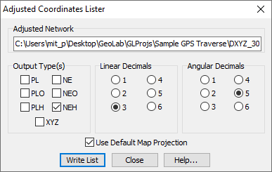
You can produce a listing of adjusted coordinates into a text tab by selecting the Adjusted coords... button on the Project/Tools tab, which displays the GeoLab Adjusted Coordinates Lister dialog box.
This dialog contains the following controls:
File name Box: This box displays the filename of the adjusted network for which you wish to generate adjusted coordinates records. You can select an adjusted network using the Browse button.
Browse Button: This button will display a dialog from which you can select an adjusted network.
Output Type Group Box: This group box contains check boxes for all the record types from which you can select. Please refer to the documentation of the PL, PLH, PLO, NE, NEH, NEO, and XYZ records for more information.
If multiple boxes are selected, the adjusted coordinates will be transformed to all of the selected types simultaneously.Linear Decimals Group Box: This group box contains radio buttons for all the linear decimal places settings from which you can select. All linear values (e.g. distances) will be formatted with the specified number of decimal places.
Angular Decimals Group Box: This group box contains radio buttons for all the angular decimal places settings from which you can select. All angular values (e.g. latitudes) will be formatted with the specified number of decimal places.
Write List Button: This button will write the adjusted coordinate records into the current text tab according to the current configuration. After the records are written, the dialog will be closed.
Close Button: This button will close the dialog box without writing the adjusted coordinates records.
Help Button: This button displays this information.